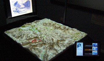
The PARM system is part of an ongoing research project at the University of Nottingham. A static physical relief model is augmented with top projection to display landscape details and to overlay with additional data visualizations. Sources: James Goulding's project page. Pristnall et al (2012). Projection Augmented Relief Models (PARM): Tangible Displays for Geographic Information.
The PARM system is part of an ongoing research project at the University of Nottingham. A static physical relief model is augmented with top projection to display landscape details and to overlay with additional data visualizations. Sources: James Goulding's project page. Pristnall et al (2012). Projection Augmented Relief Models (PARM): Tangible Displays for Geographic Information.
Added by: Yvonne Jansen, sent by: Stuart Reeves.
Category:
Active physical visualization
Tags:
cartographic, hybrid, solid terrain model, top projection