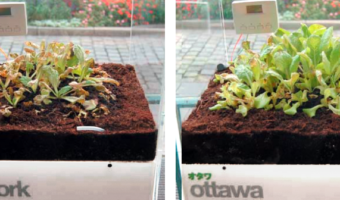
Garden of Eden consists of eight lettuces, each of which is enclosed in its own air-tight plexiglas box and represents a major city. The concencration of ozone in each box is controlled in real-time to reflect the current pollution level in the city. Sources: Thorsten Kiesl, Harald Moser, and Timm-Oliver Wilks (2007) Garden of Eden (web page) Thorsten Kiesl, Harald Moser, and Timm-Oliver Wilks (2007) Garden of Eden (paper)
2015 – Dataseeds: Flying Data
The dataseeds are a translation of data on ‘falls on and from stairs and steps, aged 50-89’. The data drives the surface area of the wing of the dataseed, which dictates the spin and falling speed of the data-object©. Source: Nick Dulake and Ian Gwilt (2015) Dataseeds - flying data
2016 – Dataponics: Human-Vegetal Play
“Dataponics: Human-Vegetal Play” maps human physical activity measured by a Fitbit to the amount of light and water fed to a potted plant. Also, the system measures the moisture in the growing hydroponic medium (in this case, expanded clay) that surrounds the plant’s roots, and plays different internet radio stations accordingly. Source: Cercos, R., Nash, A., Yuille, J., Goddard, W. (2016) Coupling quantified bodies: affective possibilities of self-quantification beyond the self
2017 – Green Berlin
Tangible data visualization of green areas and water in Berlin. "Green Berlin" is a living map showing parks and forests in Berlin. The green areas on the wooden map are laser cut, with moss growing through the holes. Source: Sebastian Meier, Green Berlin
2018 – Harassment Plants
Harassment Plants is a situated physicalization exhibited in a Brazilian city to represent stories of harassment experienced by women in a public lakeside. Each vase represents a different category of harassment and contains glyphs that represent cases of harassment. The color in the middle of the vase corresponds to the type of harassment, which is also represented by the same color in one of the beads. Each glyph is composed of a rod — whose length represents the time of the day the […]
2018 – Living Map: Precipitation Visualized with Moss
Climate change is a very hot topic nowadays. We are facing extreme weather events more and more frequently. Unusual temperatures, excess rainfall or extremely strong winds, forest fires disrupt our habitual life. The LIVING MAP visualizes the change of summertime rainfall in Europe. A precipitation data comes from the European Environmental Agency. The data was derived using climate simulation model. It compares summer precipitation in the period 1971-2000 and 2071-2100. The simulation of […]