Tag: Pierre Dragicevic

1820 – Papier-Mâché Anatomical Models

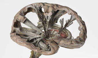
Left image: As part of its 2014 exhibition entitled Mind Maps: Stories from Psychology, the London Science Museum showcased this very accurate and intricate papier-mâché brain model from 1900 that shows path of nerve fibers. French physician Louis Thomas Jerôme Auzoux developed this technique around 1820 due to the shortage of human cadavers and wax models to study human anatomy. He was inspired by papier-mâché dolls that were common at the time. His models became popular in schools, […]

Added by: Pierre Dragicevic, sent by: Tobias Isenberg. Category: Physical model  Tags: anatomy, hand-made, model, papier-mâché, rearrangeable, science


2004 – Of All the People in All the World: Stats with Rice

Since around 2004 the British group of artists Stan’s Cafe is creating data landscapes all over the world by mapping each grain of rice to a person in order to convey various statistics such as city populations or deaths in the holocaust. The size and theme of the show change depending on the location. The largest one involved 104 tons of rice. Rice is weighted manually in small quantities and manually poured over piles. This labor-intensive process is part of the show. Sources: Stan's […]


2006 – RoomQuake: Earthquake Visualization for the Classroom

Styrofoam balls hung from classroom ceiling representing the epicenters (location), magnitudes (diameter and color), and depths (length of the string) of a series of simulated earthquakes in a fifth grade classroom. Source: Tom Moher (2006) Embedded Phenomena: Supporting Science Learning with Classroom-sized Distributed Simulations.

Added by: Pierre Dragicevic, sent by: Tom Moher. Category: Passive physical visualization  Tags: earthquake, education, hand-made, styrofoam, walkable


2012 – Grand Old Party: Political Satire

American designer Matthew Epler shows how to build physical visualizations out of silicone using 3D printing and mold casting. He also shows how to use them to make political statements. Source: Matthew Epler (2012) Grand Old Party (video here).

Added by: Pierre Dragicevic, sent by: Fanny Chevalier. Category: Passive physical visualization  Tags: 3d printing, adult toy, digital fabrication, extruded 2d, moulding, opinion polls, politics, satire, silicone


2012 – Data Cuisine

The left image is a map that shows the differences in alcohol consumption across Finland, as well as typical local food. The right image shows the number of immigrants in Finland by nationality (rice for the Chinese, salmon for the Swedish). Many other examples of edible physical visualizations can be found on the Data Cuisine web site. Data Cuisine is a series of workshops organized by Moritz Stefaner and prozessagenten. Seven workshops took place so far, the first one was in Helsinki in 2012. […]

Added by: Pierre Dragicevic, sent by: Romain DiVozzo. Category: Passive physical visualization  Tags: cartographic, data cuisine, edible, food, world stats


2012 – Slime Mold Imitates the United States Interstate System

Can a slime mold solve the traveling salesman problem without a digital computer? From the article's abstract: The plasmodium phase of Physarum polycephalum is a champion amongst living creatures used in laboratory prototypes of future and emergent computing architectures. A wide range of problems from computational geometry and logic can be solved by this cellular slime mold. A typical way to perform a computation with the slime mold is to represent a problem’s data as a spatial configuration […]

Added by: Jonathan Helfman & Pierre Dragicevic. Category: Uncertain  Tags: cartographic, indexical, mold, physical computation, traveling salesman


2013 – Pneumatic Charts

The Hive Big Data Think Tank at Palo Alto created a device for visualizing city data (power, waste, demographic, transportation) using blowers, microcontrollers and ping pongs balls. Sources: Lance Riedel, Christophe Briguet, Srinivas Doddi, Daniel Schwartz, Pashu Christensen, The Hive @City Camp Palo Alto for the National Day of Civic Hacking! Svetlana Sicular (2013) Now Open.

Added by: Pierre Dragicevic, sent by: Benjamin Bach. Category: Active physical visualization  Tags: city data, ping pong ball, pneumatic


2013 – Very Pointy Elevation Map

Toronto-based startup DataAppeal, which develops Web apps for 3D geo-spatial data visualization, created this very pointy stalagmite-looking elevation map of GTA Transit volume in Toronto. Sources: Andy Kirk (2013) 3D Printing Capabilility via DataAppeal Maps. Candice So (2013) Data visualizations go from flat to 3D.


2014 – Abyss Table - Scale Model of Deep Sea as Furniture

This table created by the furniture design company Duffy London is a geological cross-section of the sea shown with layered wood and glass sheets. Designer Christopher Duffy got the idea while visiting a glass factory and noticing that glass sheets darken as more layers as added, as does the sea. You can have this piece of furniture at home for £9,800. Sources: Duffy London (2014) Abyss Table. Nina Azzarello (2014) Duffy London layers the abyss table to look like ocean depths.

Added by: Pierre Dragicevic, sent by: Samuel Huron. Category: Physical model  Tags: cartographic, cartography, commercial, furniture, geography, sea, glass


2014 – Data Crystals: Conglomerated World Stats

During his residency at Autodesk, artist Scott Kildall created crystal-looking data sculptures by turning world data such as city populations into small cubes laid out on an Earth globe, then running a force-directed algorithm that conglomerates them into a monolithic structure that can be 3D-printed. The image above shows the 2500 nuclear detonations in recorded history, two of which (the black dots) are the bombs dropped at Hiroshima and Nagasaki, the only ones used as weapons. Source: Scott […]