Hans Rosling is famous worldwide for his fascinating speeches about population growth and income inequalities, notably his 2006 TED Talk where he debunks myths about the third world using animated charts. In 2010 he started to tell stories about data using physical visualizations. He started by stacking Ikea boxes, then switched to a variety familiar objects including pebbles, toy construction kits, fruit juice, snow balls and even toilet paper. Hans' son Ola Rosling is behind the technology […]
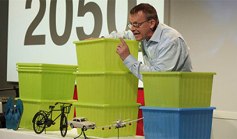
Hans Rosling is famous worldwide for his fascinating speeches about population growth and income inequalities, notably his 2006 TED Talk where he debunks myths about the third world using animated charts. In 2010 he started to tell stories about data using physical visualizations. He started by stacking Ikea boxes, then switched to a variety familiar objects including pebbles, toy construction kits, fruit juice, snow balls and even toilet paper. Hans' son Ola Rosling is behind the technology and scenography used in his talks. Both strongly believe in the pedagogical power of physical visualizations. Hans Rosling told us that: physical props reach the mind of a large part of the public because thats how you represent data in daily life at the kitchen table, at the cafe and in the bar. Click on the links below to see the full videos (same order as the images above): Hans Rosling's TED talk (2010) Global population growth, box by box. Via infosthetics. Herbert Reininger (2012) Hans Rosling's shortest TED talk. SVT (2012) Hans Rosling i SVT Agenda (in Swedish). The Guardian (2013) Population growth and climate change explained by Hans Rosling. Hans Rosling (2013) Mariam Claeson, Hans Rosling and René Loewenson at Global Health. BBC Newsnight (2013) Hans Rosling on the consequences of population growth. Wingspan Productions (2013) Don't Panic (at 25 min). Hans Rosling (2014) Will saving poor children lead to overpopulation?. Karolinska Institutet (2014) Bill Gates and Hans Rosling debate the end of extreme poverty (at 29 min). Gapminder Foundation (2014) Hans Rosling's Demographic Party Trick #1. BBC Newsnight (2015) Hans Rosling on global income disparity (and snowballs). Gapminder (2015) How many are rich and how many are poor? Gapminder (2015) Where do people live? Gapminder (2015) The rapid growth of the world population, when will it slow down? Thanks to Fernanda Drumond and Ola Rosling from the Gapminder Foundation for sending us some of the videos.