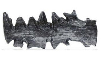
These three-dimensional maps were carved by inuits from the Ammassalik Fjord in Greenland, and used as eyes-free guides for sailing. The left one shows coastline, the right one shows a sequence of offshore islands. These inuit communities had had no direct contact with Europeans before a Danish explorer met them in 1885 and was shown the wooden maps. Sources: Bill Buxton (2007). Sketching User Experiences. page 36. Wikipedia. Ammassalik wooden maps.
These three-dimensional maps were carved by inuits from the Ammassalik Fjord in Greenland, and used as eyes-free guides for sailing. The left one shows coastline, the right one shows a sequence of offshore islands. These inuit communities had had no direct contact with Europeans before a Danish explorer met them in 1885 and was shown the wooden maps. Sources: Bill Buxton (2007). Sketching User Experiences. page 36. Wikipedia. Ammassalik wooden maps.
Added by: Pierre Dragicevic.
Category:
Physical model
Tags:
Ammassalik, cartographic, tactile map, wooden map