“Also know as the “Dymaxion Map,” the Fuller Projection Map is the only flat map of the entire surface of the Earth which reveals our planet as one island in one ocean, without any visually obvious distortion of the relative shapes and sizes of the land areas, and without splitting any continents. It was developed by R. Buckminster Fuller. All flat world map representations of the spherical globe contain some amount of distortion either in shape, area, distance or direction […]
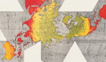
“Also know as the “Dymaxion Map,” the Fuller Projection Map is the only flat map of the entire surface of the Earth which reveals our planet as one island in one ocean, without any visually obvious distortion of the relative shapes and sizes of the land areas, and without splitting any continents. It was developed by R. Buckminster Fuller.
All flat world map representations of the spherical globe contain some amount of distortion either in shape, area, distance or direction measurements. On the well-known Mercator world map, Greenland appears to be three times its relative globe size and Antarctica appears as a long thin white strip along the bottom edge of the map. Even the popular Robinson Projection, now used in many schools, still contains a large amount of area distortion with Greenland appearing 60 percent larger than its relative globe size.”
Fuller’s view was that given a way to visualize the whole planet with greater accuracy, we humans will be better equipped to address challenges as we face our common future aboard Spaceship Earth.
The word Dymaxion, Spaceship Earth and the Fuller Projection Map are trademarks of the Buckminster Fuller Institute. All rights reserved."
Source: Buckminster Fuller Institute
Related: Also see our other entries on physical globes and maps.
Added by: Alex Hughes.
Category:
Physical model
Tags:
Cartographic, Globe, Dymaxion, Buckminster Fuller