Tag: City

1991 – Münster Congestion Visualization

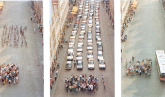
In order to encourage bus use, in 1991 the city of Münster, Germany created a poster that compares the space taken by 72 bicycles (left), 72 cars (middle), and a bus (right). This idea is not new. For example, the city of London has made a very similar poster in 1965. Thanks to Will Stahl-Timmins for pointing this out. Sources: Benjamin Starr (2014) How Much Space Do Cars Take? Cyclists Demonstrate How Bicycles Flight Congestion Image from visualnews.com

Added by: Pierre Dragicevic. Category: Passive physical visualization  Tags: city, participatory, people, rearrangement, traffic, transportation


2008 – 100% City

Since 2008, the German theater group Rimini Protokoll organizes performances where they select 100 people in such a way that they form a representative sample of a given city, and then invites them on the stage. Each person briefly introduces themselves, after which everyone participates in a series of physical visualizations where each person takes the role of a data point. The first performance was titled 100% Berlin. Similar performances were then organized in 18 other cities between 2010 […]

Added by: Pierre Dragicevic. Category: Active physical visualization  Tags: city, participatory, people


2021 – Walkable Bar Chart

A bar chart conveying two quantities, one of which is clearly larger. The activists and artists at the Respect New Haven rally yesterday offered this stunning graphic to visualize Yale's $32 Billion endowment compared to its paltry $13 million contribution to the city of New Haven...a FRACTION of the taxes it would pay if properly assessed. Source: Tweet from Davarian L. Baldwin. Related: Also see our other entries on walkable physical visualizations.

Added by: Pierre Dragicevic & Yvonne Jansen, sent by: Benjamin Bach. Category: Passive physical visualization  Tags: walkable, city, politics, taxes, bar chart, street, paint


2024 – Bike Repair Stations as 3D Sculptures

Making the Invisible Visible is a project that tracks cyclists’ routes throughout the city and transforms this data into three-dimensional sculptures that double as public bike repair stations. These sculptural objects not only enhance public space and act as reference points for urban navigation, but also invite cyclists to reflect on bicycle movement across Quito (Ecuador) while repairing their bikes. Sources: Barriga-Abril, X., Vivanco, J., Rosas, C., Medina, X., Aulestia, A., & […]

Added by: Xavier Barriga-Abril. Category: Passive physical visualization  Tags: cartographics, bicycle, urban, situated, city, data sculpture, steel