Tag: Large-Scale

1980 – People on a Giant World Map

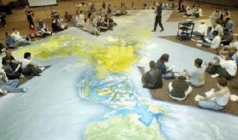
The World Game Workshop used a giant (basketball court size) world map to display population growth, distribution, and density, energy use, food and a host of other global variables and problems. 100 people were placed on the map, located where humanity is currently in the world, each one representing 1% of the global population. They were then placed in charge of their region and given the responsibility of solving the world’s problems. Sources: Post by Medard Gabel, Executive Director, […]


1999 – World's Largest Solid Terrain Model

In 2006, a mysterious 900x700m solid terrain model with military facilities was discovered by a German Google Earth user next to the Chinese town of Huangyangtan. It was quickly identified as a 1:500 replica of a disputed area in Tibet between China and India 2400km away, with perfectly matching orientation. Chinese authorities claimed the model was built 7-8 years earlier as a tank training facility. It is unclear whether the right image represents the same model. Sources: Newswatch (2011) The […]

Added by: Pierre Dragicevic. Category: Physical model  Tags: cartographic, large-scale, military, pragmatic, terrain model, walkable


2007 – Global Cities: Elevation Maps of City Population

Large-scale physical density models where plywood forms represent the populations of 12 of the world’s major urban centres. Made by a team of designers and architects led by Professor Richard Burdett. Source: Eliza Williams (2007) Global Cities at Tate Modern. Right photo by Stefan Geens.

Added by: Pierre Dragicevic. Category: Passive physical visualization  Tags: cartographic, data sculpture, large-scale, population, walkable


2010 – Shanghai Spheres

For the 2010 World Expo at Shanghai, Japanese firms ADK and Murayama and Las-Vegas firm Fisher Technical Services, Inc. created an array of 1,008 15cm diameter actuated spheres, each suspended by its own micro winch. The show does not include data visualizations. Kinetic sculptures made of arrays of suspended spheres abound. An early one is Joe Gilbertson's (2007). More recent ones include Kinetic Rain (2012) and Triptych (2014). Also check 2008 – BMW Kinetic Sculpture on this list. Source: […]

Added by: Pierre Dragicevic. Category: Enabling technology  Tags: large-scale, self-actuated, shape display


2015 – London Eye Chart: A 135m Tall Donut Chart

One week before the UK general election of 2015, the design studio Bompas & Parr and Facebook turned the Ferris wheel of London into a giant donut chart of the political parties most discussed on Facebook. Blue stands for the Conservative Party and red stands for the Labour Party. Learn more. Sources: Bompas & Parr (2015) London Eye Chart. Photo by Bompas & Parr.

Added by: Pierre Dragicevic, sent by: Loren Madsen. Category: Passive physical visualization  Tags: large-scale, pie chart, politics, social networks