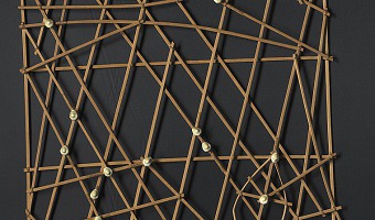
These physical visualizations show ocean swell patterns, and were built by native Micronesians from the Marshall Islands to facilitate canoe navigation. They were memorized before trips. The Western world remained unaware of the existence of these artifacts until 1862. The photo above is a stick chart from 1974. Straight sticks represent regular currents and waves, curved sticks represent ocean swells, and seashells represent atolls and islands. Sources: Wikipedia. Marshall Islands Stick […]
These physical visualizations show ocean swell patterns, and were built by native Micronesians from the Marshall Islands to facilitate canoe navigation. They were memorized before trips. The Western world remained unaware of the existence of these artifacts until 1862. The photo above is a stick chart from 1974. Straight sticks represent regular currents and waves, curved sticks represent ocean swells, and seashells represent atolls and islands. Sources: Wikipedia. Marshall Islands Stick Charts. Photo above from the National Library of Australia.
Added by: Pierre Dragicevic.
Category:
Passive physical visualization
Tags:
anthropology, cartographic, marshall islands, stick chart