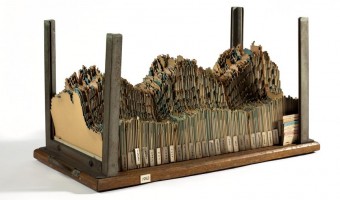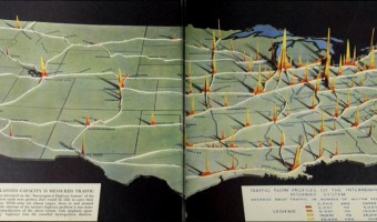
2D area diagrams encoding average daily traffic as height and color are set up along their respective highways on a background map of the US. Background map seems to be a cut-out wooden panel; area diagrams potentially cardboard, or also wood veneer. Source: In: Fortune, June 194, pp. 94-95. Original by-line reads "Map by PRA. Photograph by Richard Carver Wood". PRA is presumably the Public Roads Administration (cf. https://en.wikipedia.org/wiki/Federal_Highway_Administration#History). Accessed […]
2D area diagrams encoding average daily traffic as height and color are set up along their respective highways on a background map of the US. Background map seems to be a cut-out wooden panel; area diagrams potentially cardboard, or also wood veneer. Source: In: Fortune, June 194, pp. 94-95. Original by-line reads "Map by PRA. Photograph by Richard Carver Wood". PRA is presumably the Public Roads Administration (cf. https://en.wikipedia.org/wiki/Federal_Highway_Administration#History). Accessed via https://archive.org/details/fortune23aprluce/page/94 (Last visit: 30 April 2019)
Added by: Till Nagel.
Category:
Passive physical visualization
Tags:
cardboard, cartograpic, map, paper, roads, traffic