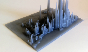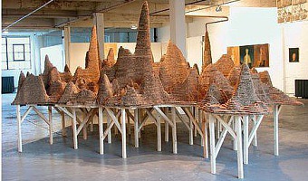
A 3D map of East London where elevation represents the rate of violent crimes between 2002 & 2003. Corrugated cardboard, 145h x 540w x 425d cm. Source: Abigail Reynolds. Mount Fear East London.
A 3D map of East London where elevation represents the rate of violent crimes between 2002 & 2003. Corrugated cardboard, 145h x 540w x 425d cm. Source: Abigail Reynolds. Mount Fear East London.
Added by: Pierre Dragicevic & Yvonne Jansen.
Category:
Passive physical visualization
Tags:
cartographic, crime, data sculpture, elevation map