“Water Works” is a 3D data visualization and mapping of the water infrastructure of San Francisco. These consist of three large-scale 3D-printed sculptures, each generated by custom C++ code. The concept behind the project is to make visible a small portion of an invisible network of pipes underneath our feet. The three physical data visualizations are: "San Francisco Cisterns", “Imaginary Drinking Hydrants” and "Sewer Works". "Sewer Works" uses 60,000 data points from San Francisco sewers and […]
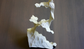
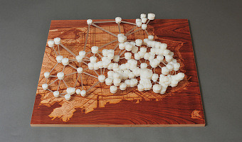
“Water Works” is a 3D data visualization and mapping of the water infrastructure of San Francisco. These consist of three large-scale 3D-printed sculptures, each generated by custom C++ code. The concept behind the project is to make visible a small portion of an invisible network of pipes underneath our feet. The three physical data visualizations are: "San Francisco Cisterns", “Imaginary Drinking Hydrants” and "Sewer Works". "Sewer Works" uses 60,000 data points from San Francisco sewers and pipes and shows the flow of wastewater and stormwater near the San Francisco Bay waterfront. "San Francisco Cisterns" maps the 170 underground cisterns of San Francisco that were mostly built in the years just after the 1906 Earthquake. "Imaginary Drinking Hydrants" depicts potable water faucets attached to specific fire hydrants for general public use. In 2006, the SFPUC created a series of “blue drop” hydrants, which would provide water in case of emergency (but without a drinking faucet). These hydrants would be opened up by city officials if there were a city-wide disaster. Just a few years after introducing 67 emergency drinking hydrants, the city unceremoniously discontinued the program. This is part of a Creative Code Fellowship sponsored by Gray Area, Stamen Design and Autodesk. Sources: Scott Kildall, Water Works Scott Kildall (blog), Water Works
Added by: Scott Kildall.
Category:
Passive physical visualization
Tags:
cartographic, cisterns, hydrants, infrastructure, san francisco, sewer, water